Ozark Highlands Trail
Ozark-Saint Francis National Forest, Arkansas
A one-way trail of 198.6 mi in Buffalo National River, Ozark-Saint Francis National Forest.
It goes up and down rather than rising steadily: about 30,600 ft of elevation gain along the way, between 500 ft and 2,360 ft.
The steepest stretch is between 189.4 mi and 189.9 mi from the trailhead, gaining 500 ft.
On the way it passes near Maumee Falls West, Walterfall Hollow Falls #3, Maumee Falls East.
Described from the map and elevation data.
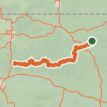
See the trail on the map, download it for offline use and record your hike. The iPhone and Android apps are on their way.
Before you go: trail information can be out of date or wrong, and a trail may be closed or on private land. Check current conditions with the land manager. You hike at your own risk. Full notice
On this hike
- Summits on this hike: Morgan Mountain
- Lakes on this hike: Lake Fort Smith
- Waterfalls on this hike: Maumee Falls West, Walterfall Hollow Falls #3, Maumee Falls East, Walterfall Hollow Falls #2, Walterfall Hollow Falls #1, Lichen Falls, Train Trestle Falls, Hobo Falls East, Bear Skull Falls, Hobo Falls West, Haw Creek Falls, Spirit Creek Falls, Intersection Falls, Slot Rock Falls, Robinson Falls, 2 unnamed waterfalls
- Rivers and creeks on this hike: Bear Creek, Cedar Creek, Fane Creek, Gee Creek, Hurricane Creek, Jack Creek, and 5 more
- Viewpoints on this hike: Little Mulberry Overlook, Tie Slide Overlook, Pileated Point, Peter Cave Overlook, 14 unnamed viewpoints
Elevation profile
Nearby trails
- Buffalo National River - Forest Trail1.7 mi · Easy · 0.9 mi away
- Buffalo National River - Overlook Trail1.8 mi · Easy · 1.2 mi away
- Return Trail2.5 mi · Easy · 1.2 mi away
- Indian Rockhouse Trail3.4 mi · Moderate · 1.2 mi away
- Campground Trail2.8 mi · Moderate · 1.3 mi away
- Mine Level Trail2.7 mi · Easy · 4.4 mi away
Camping nearby
- Group Campground0.8 mi from the trailhead
- Buffalo Point Campground1.3 mi from the trailhead
- Buffalo Point1.5 mi from the trailhead
- Rush Campground4.3 mi from the trailhead