Backbone Trail
Santa Monica Mountains National Recreation Area, California
A one-way trail of 50.1 mi in Castro Crest, Circle X Ranch.
It goes up and down rather than rising steadily: about 10,770 ft of elevation gain along the way, between 40 ft and 3,000 ft.
The steepest stretch is between 9.4 mi and 9.9 mi from the trailhead, gaining 390 ft.
On the way it passes near Newton Canyon Falls, Boney Mountain State Wilderness, Zuma Canyon Falls.
The trailhead is about 11.1 mi south-east of Oxnard in a straight line.
There are 2 campgrounds within 2 mi of the trailhead; the nearest is Hike and Bike Campsites.
Described from the map and elevation data.
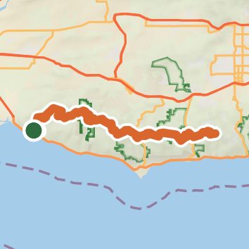
See the trail on the map, download it for offline use and record your hike. The iPhone and Android apps are on their way.
Before you go: trail information can be out of date or wrong, and a trail may be closed or on private land. Check current conditions with the land manager. You hike at your own risk. Full notice
On this hike
- Summits on this hike: McAuley Peak
- Waterfalls on this hike: Newton Canyon Falls, Zuma Canyon Falls
- Rivers and creeks on this hike: Big Sycamore Creek, Zuma Creek
Elevation profile
Nearby trails
- Scenic Trail1.4 mi · Easy · 1.5 mi away
- Fireline Trail4.1 mi · Moderate · 1.5 mi away
- Great Dune View Trail1.5 mi · Easy · 1.6 mi away
- Mugu Peak Trail7.1 mi · Hard · 1.7 mi away
- La Jolla Valley Loop Trail8.5 mi · Hard · 1.7 mi away
- Chumash Trail1.2 mi · Easy · 1.7 mi away
Camping nearby
- Hike and Bike Campsites1.5 mi from the trailhead
- Sycamore Canyon Campground1.5 mi from the trailhead
- Danielson Group Multi-Use Campground3.7 mi from the trailhead
- Sycamore Group Multi-Use Area4.2 mi from the trailhead