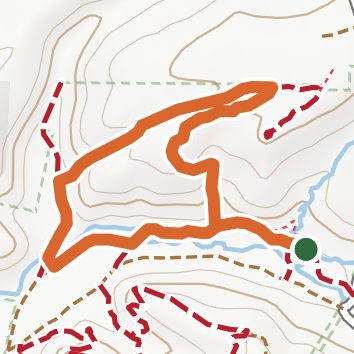
Coyote Loop
Quigley Canyon Open Space, California
1.5 miLength
310 ftElevation gain
EasyDifficulty
LoopRoute
A loop of 1.5 mi in Quigley Canyon Open Space.
It gains 310 ft of elevation in all, between a low point of 1,310 ft and a high point of 1,620 ft about 0.6 mi in.
The trailhead is about 2.2 mi east of Santa Clarita in a straight line.
Described from the map and elevation data.
Open in Sahale GPS
See the trail on the map, download it for offline use and record your hike. The iPhone and Android apps are on their way.
Before you go: trail information can be out of date or wrong, and a trail may be closed or on private land. Check current conditions with the land manager. You hike at your own risk. Full notice
Elevation profile
Low 1,310 ft1.5 miHigh 1,620 ft
Nearby trails
- Fox Loop0.9 mi · Easy · same trailhead
- Rawlin's Loop0.8 mi · Easy · 0.3 mi away
- Clean Energy Systems Trail1.3 mi · Easy · 0.3 mi away
- Oro Fino Trail0.9 mi · Easy · 0.5 mi away
- City Loop0.9 mi · Easy · 0.5 mi away
- North Path0.5 mi · Easy · 1.4 mi away
Camping nearby
- Group Campground 11.7 mi from the trailhead
- Group Campground 21.8 mi from the trailhead
- Group Campground 31.8 mi from the trailhead
- Group Campground 41.9 mi from the trailhead