Dragon Lake Trail
Kings Canyon National Park, California
An out-and-back in Kings Canyon National Park, John Muir Wilderness, 25.8 mi round trip.
It goes up and down rather than rising steadily: about 4,610 ft of elevation gain on the way out, between 9,180 ft and 11,980 ft, ending near Dragon Lake.
The steepest stretch is the last 0.5 mi, which gains 490 ft.
On the way it passes near Gilbert Lake, Flower Lake, Little Pothole Lake.
Described from the map and elevation data.
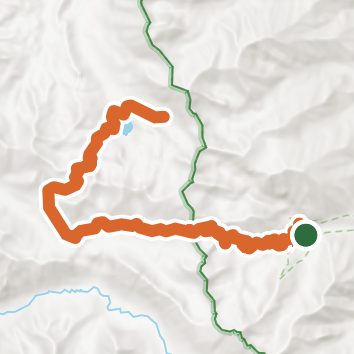
See the trail on the map, download it for offline use and record your hike. The iPhone and Android apps are on their way.
Before you go: trail information can be out of date or wrong, and a trail may be closed or on private land. Check current conditions with the land manager. You hike at your own risk. Full notice
On this hike
- Lakes on this hike: Middle Rae Lake, Upper Rae Lake, Dragon Lake, Gilbert Lake, Flower Lake, Little Pothole Lake
- Rivers and creeks on this hike: South Fork Woods Creek
Elevation profile
Nearby trails
- Charlotte Lake Trail17.2 mi · Strenuous · same trailhead
- Junction Pass Trail33.1 mi · Strenuous · same trailhead
- Lower Sixty Lakes Basin Trail29.7 mi · Strenuous · same trailhead
- Kearsarge Pass Trail15 mi · Strenuous · same trailhead
- Golden Trout Lake North Spur Trail5 mi · Hard · same trailhead
- Kearsarge Lakes Trail12.5 mi · Strenuous · same trailhead
Camping nearby
- Onion Valley0.3 mi from the trailhead
- Grays Meadows2.6 mi from the trailhead
- Upper Grays Meadow Campground2.9 mi from the trailhead
- Lower Grays Meadow Campground3.2 mi from the trailhead