Elk Lake Trail
Yolla Bolly-Middle Eel Wilderness, California
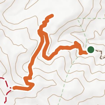
A loop of 5.1 mi in Yolla Bolly-Middle Eel Wilderness, Mendocino National Forest.
It gains 1,400 ft of elevation in all, between a low point of 5,380 ft and a high point of 6,690 ft about 2.8 mi in.
The steepest stretch is between 2.3 mi and 2.8 mi from the trailhead, gaining 460 ft.
On the way it passes near Elk Lake.
Green Springs Campground is within 2 mi of the trailhead.
Described from the map and elevation data.
See the trail on the map, download it for offline use and record your hike. The iPhone and Android apps are on their way.
Before you go: trail information can be out of date or wrong, and a trail may be closed or on private land. Check current conditions with the land manager. You hike at your own risk. Full notice
On this hike
- Lakes on this hike: Elk Lake
Elevation profile
Nearby trails
- Hammerhorn Ridge Cutoff7.7 mi · Hard · 1.6 mi away
- Hammerhorn Ridge Trail14 mi · Strenuous · 1.6 mi away
- Yolla Bolly-Middle Eel Wilderness - Summit Trail15.3 mi · Strenuous · 1.6 mi away
- Smokehouse Ridge Trail7.1 mi · Hard · 3.4 mi away
- Key Spot Trail1.2 mi · Easy · 4.4 mi away
- Hammerhorn Lake Trail0.8 mi · Easy · 5.0 mi away
Camping nearby
- Green Springs Campground1.5 mi from the trailhead
- Hammerhorn Campground4.9 mi from the trailhead
- Little Doe Campground7.7 mi from the trailhead
- Three Prong Campground8.3 mi from the trailhead