Firebreak
San Gabriel Mountains National Monument, California
An out-and-back in Monrovia Hillside Wilderness Preserve, San Gabriel Mountains National Monument, 18.8 mi round trip.
It goes up and down rather than rising steadily: about 6,210 ft of elevation gain on the way out, between 1,390 ft and 5,410 ft, ending near Pine Mountain.
The steepest stretch is between 1.1 mi and 1.6 mi from the trailhead, gaining 1,000 ft.
The trailhead is about 1.9 mi north of Monrovia in a straight line.
Described from the map and elevation data.
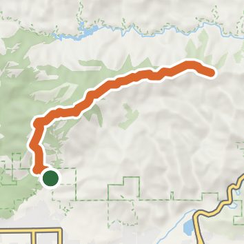
See the trail on the map, download it for offline use and record your hike. The iPhone and Android apps are on their way.
Before you go: trail information can be out of date or wrong, and a trail may be closed or on private land. Check current conditions with the land manager. You hike at your own risk. Full notice
On this hike
- Summits on this hike: Monrovia Peak, Rankin Peak
Elevation profile
Nearby trails
- Monrovia Hillside Wilderness Preserve - Nature Trail0.5 mi · Easy · same trailhead
- Bill Cull Trail1.3 mi · Easy · same trailhead
- San Gabriel Mountains National Monument - Falls Trail1.5 mi · Easy · 0.2 mi away
- Ben Overturff Trail4 mi · Moderate · 0.8 mi away
- Twin Springs3.2 mi · Moderate · 0.8 mi away
- Cactus Cooler1.1 mi · Easy · 1.1 mi away
Camping nearby
- Spring Camp2.9 mi from the trailhead
- Hoegee's camp3.3 mi from the trailhead
- DAD's Camping5.5 mi from the trailhead
- Henninger Flats5.7 mi from the trailhead