Pacific Crest Trail
California, Oregon, Washington, California
A one-way trail of 2,614.5 mi in California, Oregon.
It goes up and down rather than rising steadily: about 318,080 ft of elevation gain along the way, between 80 ft and 12,820 ft, ending near Lake Sally Ann.
On the way it passes near Rockpile Lake, Sheep Lake, Sheep Lakes.
The trailhead is about 1.2 mi south of Campo in a straight line.
There are 2 campgrounds within 2 mi of the trailhead; the nearest is Cleef campground, 15p/p.
Described from the map and elevation data.
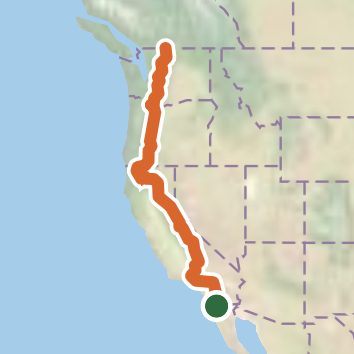
See the trail on the map, download it for offline use and record your hike. The iPhone and Android apps are on their way.
Before you go: trail information can be out of date or wrong, and a trail may be closed or on private land. Check current conditions with the land manager. You hike at your own risk. Full notice
On this hike
- Summits on this hike: Berry Mountain, Blowout Mountain, Chimney Rock, Grizzly Peak, Koosah Mountain, Shale Butte, and 1 more
- Lakes on this hike: Baum Lake, Blue Lake, Brahma Lake, Cigar Lake, Dollar Lake, Dorothy Lake, and 110 more
- Waterfalls on this hike: Rock Creek Falls, Cooper Canyon Falls, Obsidian Falls, Upper Evolution Creek Falls, Tuolumne Falls, Loves Falls, Aztec Falls, White Cascade, Hesperia Falls, Pacific Crest Falls, Paradise Branch Falls, Burney Falls, 5 unnamed waterfalls
- Rivers and creeks on this hike: Agua Caliente Creek, Arrastre Creek, Bear Creek, Bridge Creek, Brush Creek, Bubbs Creek, and 68 more
- Viewpoints on this hike: Islip Saddle Day Use Area and Trailhead, Park Ridge, Zigzag Canyon Rim, Kendall Katwalk, Sourdough Gap, Eagle rock, and 2 more, 23 unnamed viewpoints
Elevation profile
Nearby trails
- PCT - California Section A106.4 mi · Strenuous · 7.0 mi away
- Greenhorn Trail4.7 mi · Moderate · 9.8 mi away
- Ranger Trail12 mi · Strenuous · 9.8 mi away
- Sodbuster Trail1.8 mi · Easy · 10.0 mi away
- Ranger Trail2.6 mi · Easy · 10.4 mi away
- Ranger Trail4.3 mi · Moderate · 10.4 mi away
Camping nearby
- Cleef campground, 15p/p0.6 mi from the trailhead
- informal campground1.6 mi from the trailhead
- 1-2 tents2.6 mi from the trailhead
- Lake Morena County Park Campground7.2 mi from the trailhead