PCT - California Section I
Yosemite National Park, California
A one-way trail of 72.2 mi in Hoover Wilderness, Yosemite Wilderness.
It goes up and down rather than rising steadily: about 14,170 ft of elevation gain along the way, between 7,590 ft and 10,860 ft, ending near Latopie Lake.
The steepest stretch is between 30.8 mi and 31.3 mi from the trailhead, gaining 450 ft.
On the way it passes near Tuolumne Falls, White Cascade, Lake Harriet.
Tuolumne Meadows Campground is within 2 mi of the trailhead.
Described from the map and elevation data.
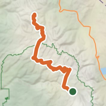
See the trail on the map, download it for offline use and record your hike. The iPhone and Android apps are on their way.
Before you go: trail information can be out of date or wrong, and a trail may be closed or on private land. Check current conditions with the land manager. You hike at your own risk. Full notice
On this hike
- Lakes on this hike: Wilma Lake, Dorothy Lake, Lake Harriet, Smedberg Lake, Miller Lake, Stella Lake
- Waterfalls on this hike: Tuolumne Falls, White Cascade
- Rivers and creeks on this hike: Falls Creek, Matterhorn Creek, Rancheria Creek, Spiller Creek, Tuolumne River, Wilson Creek
Elevation profile
Nearby trails
- High Sierra Camp Loop47.4 mi · Strenuous · same trailhead
- Young Lakes via Dog Lake Trail8.8 mi · Hard · same trailhead
- Upper Young Lake Trail13.5 mi · Strenuous · same trailhead
- Puppy Boulders Approach0.4 mi · Easy · 0.4 mi away
- Soda Spring Acesss0.8 mi · Easy · 0.5 mi away
- Nelson Lake Use Trail10.6 mi · Strenuous · 0.5 mi away
Camping nearby
- Tuolumne Meadows Campground0.5 mi from the trailhead
- Tioga Lake Campground6.4 mi from the trailhead
- Junction Campground7.0 mi from the trailhead
- Sawmill Walk-in Campground7.2 mi from the trailhead