PCT - California Section J
Humboldt–Toiyabe National Forest, California
A one-way trail of 74.1 mi in Mokelumne Wilderness, Lake Tahoe Basin Management Unit.
It goes up and down rather than rising steadily: about 15,180 ft of elevation gain along the way, between 7,220 ft and 10,510 ft, ending near Wolf Creek Lake.
The steepest stretch is between 4.8 mi and 5.3 mi from the trailhead, gaining 450 ft.
On the way it passes near Sherrold Lake, Lower Echo Lake, Showers Lake.
The trailhead is about 7.5 mi south-west of South Lake Tahoe in a straight line.
Described from the map and elevation data.
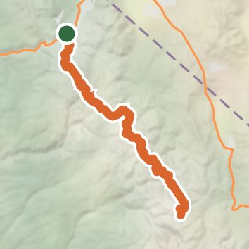
See the trail on the map, download it for offline use and record your hike. The iPhone and Android apps are on their way.
Before you go: trail information can be out of date or wrong, and a trail may be closed or on private land. Check current conditions with the land manager. You hike at your own risk. Full notice
On this hike
- Lakes on this hike: Lower Echo Lake, Lily Pad Lake, Showers Lake, Noble Lake, Asa Lake
- Waterfalls on this hike: 1 unnamed waterfall
- Rivers and creeks on this hike: East Fork Carson River, South Fork American River, Upper Truckee River
Elevation profile
Nearby trails
- Tahoe Rim Trail163.2 mi · Strenuous · same trailhead
- Meyers Multipitch1.1 mi · Easy · 0.6 mi away
- Gunmount Trail0.5 mi · Easy · 0.6 mi away
- Johnson Pass Trail0.5 mi · Easy · 0.9 mi away
- Ridge Path0.3 mi · Easy · 0.9 mi away
- Warr Trail5.8 mi · Hard · 1.4 mi away
Camping nearby
- Luther Pass Campground3.3 mi from the trailhead
- Camp Sacramento4.5 mi from the trailhead
- Tahoe Valley Campground5.7 mi from the trailhead
- Lovers Leap Campground5.8 mi from the trailhead