Rush Creek Trail
Ansel Adams Wilderness, California
An out-and-back in Ansel Adams Wilderness, Inyo National Forest, 18.2 mi round trip.
It gains 2,950 ft over 8.9 mi, from 7,250 ft at the trailhead to 9,540 ft.
The steepest stretch is between 0.9 mi and 1.4 mi from the trailhead, gaining 400 ft.
On the way it passes near Billy Lake, Horsetail Falls, Agnew Lake.
The trailhead is about 12.5 mi north-west of Mammoth Lakes in a straight line.
Silver Lake Campground June Lake (CA) is within 2 mi of the trailhead.
Described from the map and elevation data.
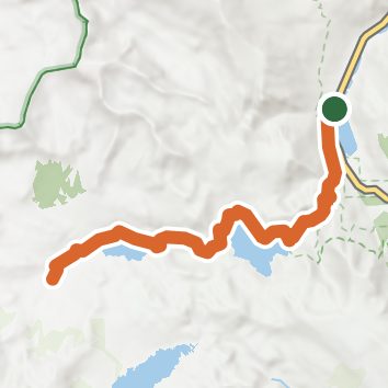
See the trail on the map, download it for offline use and record your hike. The iPhone and Android apps are on their way.
Before you go: trail information can be out of date or wrong, and a trail may be closed or on private land. Check current conditions with the land manager. You hike at your own risk. Full notice
On this hike
- Lakes on this hike: Billy Lake, Waugh Lake, Gem Lake, Agnew Lake, Silver Lake
- Waterfalls on this hike: 1 unnamed waterfall
- Rivers and creeks on this hike: Rush Creek
- Viewpoints on this hike: View on Silver Lake
Elevation profile
Nearby trails
- Parker Bench Trail9.9 mi · Strenuous · 0.3 mi away
- Gem Pass Snow Bypass Trail13.3 mi · Strenuous · 0.4 mi away
- Weber Lake Trail14.6 mi · Strenuous · 0.4 mi away
- Weber Lake Spur14.6 mi · Strenuous · 0.4 mi away
- Alger Lakes Trail27.8 mi · Strenuous · 0.4 mi away
- Thousand Island Lake16.4 mi · Strenuous · 0.4 mi away
Camping nearby
- Silver Lake Campground June Lake (CA)0.3 mi from the trailhead
- Gull Lake Campground2.6 mi from the trailhead
- Reversed Creek Campground2.6 mi from the trailhead
- June Lake3.0 mi from the trailhead