Stone Ridge Spine Path
Ventana Wilderness, California
8.4 miLength
4,110 ftElevation gain
StrenuousDifficulty
Out & BackRoute
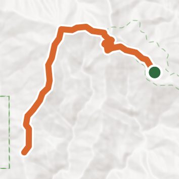
An out-and-back in Ventana Wilderness, Los Padres National Forest, 8.4 mi round trip.
It gains 860 ft in the first 2.2 mi to a high point at 4,840 ft, then drops 2,570 ft to Limekiln State Wilderness; that drop is more elevation gain on the way back.
There are 2 campgrounds within 2 mi of the trailhead; the nearest is Vicente Flat Camp.
Described from the map and elevation data.
Open in Sahale GPS
See the trail on the map, download it for offline use and record your hike. The iPhone and Android apps are on their way.
Before you go: trail information can be out of date or wrong, and a trail may be closed or on private land. Check current conditions with the land manager. You hike at your own risk. Full notice
On this hike
- Summits on this hike: Twin Peak
Elevation profile
Low 2,280 ft8.4 miHigh 4,840 ft
Nearby trails
- Cone Peak Summit Trail3.7 mi · Moderate · same trailhead
- Cone Peak Trail6.2 mi · Hard · same trailhead
- Carrizo Trail14.1 mi · Strenuous · 0.7 mi away
- North Coast Ridge Trail20.4 mi · Strenuous · 0.7 mi away
- Stone Ridge Trail17.9 mi · Strenuous · 1.1 mi away
- San Antonio Trail2.8 mi · Moderate · 1.1 mi away
Camping nearby
- Vicente Flat Camp1.0 mi from the trailhead
- Trail Spring Camp1.4 mi from the trailhead
- Espinosa Camp2.1 mi from the trailhead
- Goat Camp2.2 mi from the trailhead