Colorado Trail
Colorado
A one-way trail of 221.3 mi in Gunnison National Forest, Rio Grande National Forest.
It goes up and down rather than rising steadily: about 42,320 ft of elevation gain along the way, between 7,000 ft and 13,250 ft, ending near Sargents Mesa.
The steepest stretch is between 84.2 mi and 84.7 mi from the trailhead, gaining 630 ft.
On the way it passes near Little Molas Lake, Cataract Lake.
Described from the map and elevation data.
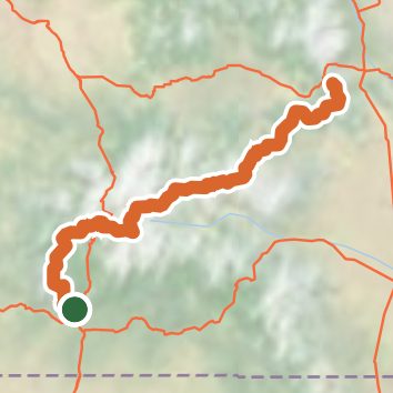
See the trail on the map, download it for offline use and record your hike. The iPhone and Android apps are on their way.
Before you go: trail information can be out of date or wrong, and a trail may be closed or on private land. Check current conditions with the land manager. You hike at your own risk. Full notice
On this hike
- Summits on this hike: Efendi Peak
- Lakes on this hike: Little Molas Lake
- Waterfalls on this hike: 1 unnamed waterfall
- Rivers and creeks on this hike: Archuleta Creek, Cochetopa Creek, Elk Creek, Flagler Fork, Junction Creek, Los Creek, and 5 more
Elevation profile
Nearby trails
- La Garita Stock Driveway Trail18.3 mi · Strenuous · 0.2 mi away
- Miner's Creek Trail11.7 mi · Strenuous · 0.2 mi away
- Skyline Trail3.9 mi · Moderate · 2.7 mi away
- Cebolla Trail1.1 mi · Easy · 2.7 mi away
- Calf Creek Plateau Trail4.5 mi · Moderate · 5.9 mi away
- Canyon Infierno Trail5.8 mi · Moderate · 6.1 mi away
Camping nearby
- Deer Lakes Campground5.7 mi from the trailhead
- Hidden Valley Tent Campground7.1 mi from the trailhead
- Wupperman Campground7.2 mi from the trailhead
- Wupperman Campground7.3 mi from the trailhead