Colorado Trail
Colorado
A one-way trail of 178.5 mi in Pike National Forest, San Isabel National Forest.
It goes up and down rather than rising steadily: about 31,170 ft of elevation gain along the way, between 5,490 ft and 12,510 ft, ending near Lily Pond.
The steepest stretch is between 107.9 mi and 108.4 mi from the trailhead, gaining 520 ft.
On the way it passes near Galena Lake, Bear Lake.
The trailhead is about 6.7 mi south-west of Roxborough Park in a straight line.
Described from the map and elevation data.
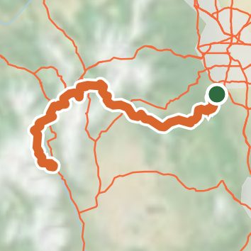
See the trail on the map, download it for offline use and record your hike. The iPhone and Android apps are on their way.
Before you go: trail information can be out of date or wrong, and a trail may be closed or on private land. Check current conditions with the land manager. You hike at your own risk. Full notice
On this hike
- Lakes on this hike: Twin Lakes
- Rivers and creeks on this hike: Buffalo Creek, Cataract Creek, Guller Creek, Miners Creek, North Fork Swan River, South Platte River, and 3 more
- Viewpoints on this hike: Searle Pass, Kenosha Pass Overlook, 2 unnamed viewpoints
Elevation profile
Nearby trails
- Russell Gulch Trail5.6 mi · Hard · 0.7 mi away
- Bear Mountain 6933 mi · Moderate · 3.0 mi away
- Platte View 693.a7.1 mi · Hard · 3.0 mi away
- Colorado Trail (Segment 1 Waterton Canyon Alternative)7.8 mi · Hard · 3.6 mi away
- Indian Creek Trail7.4 mi · Hard · 3.7 mi away
- Ringtail Trail #69914.4 mi · Strenuous · 3.9 mi away
Camping nearby
- Indian Creek Equestrian Campground3.2 mi from the trailhead
- Osprey Campground3.6 mi from the trailhead
- Rampart Range Recreation Area Designated Dispersed Camping4.3 mi from the trailhead
- Idylease Campground5.1 mi from the trailhead