East Inlet Trail
Rocky Mountain National Park, Colorado
A loop of 18.2 mi in Rocky Mountain Wilderness, Rocky Mountain National Park.
It gains 2,950 ft of elevation in all, between a low point of 8,390 ft and a high point of 10,840 ft about 9.2 mi in.
The steepest stretch is between 8.5 mi and 9 mi from the trailhead, gaining 440 ft.
On the way it passes near Adams Falls, Fifth Lake, Spirit Lake.
The trailhead is about 17.5 mi south-west of Estes Park in a straight line.
Described from the map and elevation data.
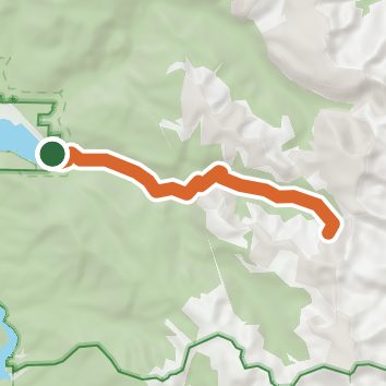
See the trail on the map, download it for offline use and record your hike. The iPhone and Android apps are on their way.
Before you go: trail information can be out of date or wrong, and a trail may be closed or on private land. Check current conditions with the land manager. You hike at your own risk. Full notice
On this hike
- Lakes on this hike: Lake Verna, Lone Pine Lake, Spirit Lake, Fifth Lake, Fourth Lake
- Waterfalls on this hike: Adams Falls, 1 unnamed waterfall
- Rivers and creeks on this hike: East Inlet
- Viewpoints on this hike: East Meadow Overlook
Elevation profile
Nearby trails
- Adams Falls Loop0.7 mi · Easy · same trailhead
- Shadow Mountain Lookout trail9.6 mi · Hard · 1.3 mi away
- Continental Divide National Scenic Trail - Rocky Mtn Park51.7 mi · Strenuous · 1.4 mi away
- Lake Nanita Trail20.7 mi · Strenuous · 1.4 mi away
- Tonahutu Creek Trail27.1 mi · Strenuous · 1.4 mi away
- Livery Tr ail1.2 mi · Easy · 1.9 mi away
Camping nearby
- Grand Lake KOA Campground2.4 mi from the trailhead
- Green Ridge3.3 mi from the trailhead
- Highway 4 Pullout Dispersed camping4.8 mi from the trailhead
- Pine Marten5.0 mi from the trailhead