N.C.A.R. Trail
National Center for Atmospheric Research, Colorado
1.5 miLength
320 ftElevation gain
EasyDifficulty
Out & BackRoute
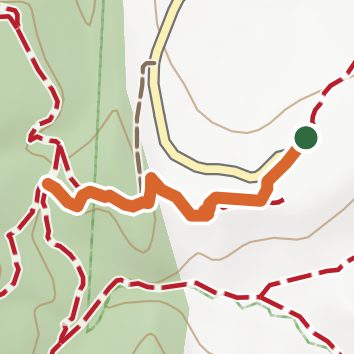
An out-and-back in National Center for Atmospheric Research, Boulder Open Space and Mountain Parks, 1.5 mi round trip.
It gains 220 ft over 0.7 mi, from 6,090 ft at the trailhead to 6,270 ft.
The trailhead is about 2.5 mi south of Boulder in a straight line.
Described from the map and elevation data.
Open in Sahale GPS
See the trail on the map, download it for offline use and record your hike. The iPhone and Android apps are on their way.
Before you go: trail information can be out of date or wrong, and a trail may be closed or on private land. Check current conditions with the land manager. You hike at your own risk. Full notice
On this hike
- Summits on this hike: Table Mountain
Elevation profile
Low 6,090 ft1.5 miHigh 6,270 ft
Nearby trails
- Mallory Cave Trail2.9 mi · Moderate · same trailhead
- N.C.A.R. - Table Mesa1.1 mi · Easy · same trailhead
- Mesa2.6 mi · Moderate · same trailhead
- Fern Canyon3.1 mi · Moderate · same trailhead
- Fern Canyon Trail5 mi · Hard · same trailhead
- Bear Canyon6.6 mi · Hard · same trailhead
Camping nearby
- Winegar Ridge Campground6.2 mi from the trailhead
- Sourdough Springs Campground10.1 mi from the trailhead
- Rifleman Phillips Group Campground10.4 mi from the trailhead
- Coyote Gulch Campground10.7 mi from the trailhead