Mattatuck Trail
Connecticut
An out-and-back in Mattatuck State Forest, White Memorial Foundation, 53.3 mi round trip.
It goes up and down rather than rising steadily: about 4,120 ft of elevation gain on the way out, between 330 ft and 1,070 ft.
The steepest stretch is between 17.3 mi and 17.8 mi from the trailhead, gaining 420 ft.
On the way it passes near Buttermilk Falls, Duck Pond, Marsh Pond.
The trailhead is about 6.8 mi south-west of Torrington in a straight line.
Described from the map and elevation data.
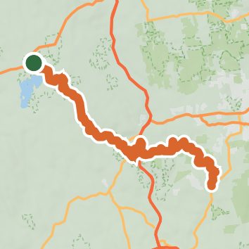
See the trail on the map, download it for offline use and record your hike. The iPhone and Android apps are on their way.
Before you go: trail information can be out of date or wrong, and a trail may be closed or on private land. Check current conditions with the land manager. You hike at your own risk. Full notice
On this hike
- Lakes on this hike: Beaver Pond, Duck Pond, Wilton Pond, Black Rock Pond, Herron Pond, Cranberry Pond, and 4 more
- Waterfalls on this hike: Buttermilk Falls
- Rivers and creeks on this hike: Bantam River, Mad River, Nibbling Brook, Purgatory Brook, Slab Meadow Brook, Todd Hollow Brook
- Viewpoints on this hike: Crane's Lookout, 2 unnamed viewpoints
Elevation profile
Nearby trails
- Little Pond Trail1.8 mi · Easy · 0.3 mi away
- Litchfield Community Greenway4.3 mi · Easy · 0.8 mi away
- Fawn Pond1.5 mi · Easy · 1.6 mi away
- Heron Pond Ridge1.2 mi · Easy · 1.6 mi away
- Beaver Pond4.9 mi · Moderate · 1.6 mi away
- Plunge Pool Trail3 mi · Easy · 1.6 mi away
Camping nearby
- Cozy Hill Campground3.0 mi from the trailhead
- Hemlock Hill Camp Resort4.9 mi from the trailhead
- Pootatuck9.0 mi from the trailhead
- Mohawk9.1 mi from the trailhead