Metacomet Trail
Connecticut
An out-and-back in City of Meriden Watershed Reserve Land, 99.3 mi round trip.
It goes up and down rather than rising steadily: about 7,620 ft of elevation gain on the way out, between 140 ft and 1,010 ft, ending near Gills Pond.
The steepest stretch is between 42.8 mi and 43.3 mi from the trailhead, gaining 360 ft.
On the way it passes near Welles Pond, Lake Louise, Gale Pond.
The trailhead is about 3 mi north-east of Simsbury Center in a straight line.
Described from the map and elevation data.
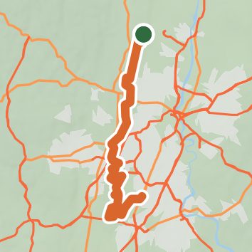
See the trail on the map, download it for offline use and record your hike. The iPhone and Android apps are on their way.
Before you go: trail information can be out of date or wrong, and a trail may be closed or on private land. Check current conditions with the land manager. You hike at your own risk. Full notice
On this hike
- Summits on this hike: Killkenny Rocks, East Peak, West Peak, Short Mountain, Ragged Mountain
- Lakes on this hike: Merimere Reservoir, Elmere Reservoir, Hartford Reservoir Number 6, Lake Louise, Gale Pond, Wassel Reservoir, and 1 more
- Rivers and creeks on this hike: Quinnipiac River
- Viewpoints on this hike: Castle Craig, 43 unnamed viewpoints
Elevation profile
Nearby trails
- Six Flags1.3 mi · Easy · 0.3 mi away
- Taj Mahal2.5 mi · Easy · 0.5 mi away
- Ernie's Run1.3 mi · Easy · 0.5 mi away
- Root Down1.1 mi · Easy · 0.6 mi away
- Inside Job1.9 mi · Easy · 0.9 mi away
- Exhibition/Twisty1.4 mi · Easy · 0.9 mi away
Camping nearby
- Primitve Camping Area4.9 mi from the trailhead
- Camp Alice Merritt9.1 mi from the trailhead
- Roaring Brook Camp Area9.2 mi from the trailhead
- DEEP campsite11.1 mi from the trailhead