Mission 22 Trail
Connecticut
26.9 miLength
3,240 ftElevation gain
StrenuousDifficulty
Out & BackRoute
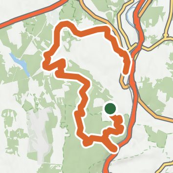
An out-and-back in Larkin State Park Trail, Naugatuck State Forest, 26.9 mi round trip.
It goes up and down rather than rising steadily: about 2,000 ft of elevation gain on the way out, between 150 ft and 800 ft, ending near Baummer Pond.
On the way it passes near Spruce Brook Falls, Barbers Pond.
The trailhead is about 1.4 mi west of Naugatuck in a straight line.
Described from the map and elevation data.
Open in Sahale GPS
See the trail on the map, download it for offline use and record your hike. The iPhone and Android apps are on their way.
Before you go: trail information can be out of date or wrong, and a trail may be closed or on private land. Check current conditions with the land manager. You hike at your own risk. Full notice
On this hike
- Summits on this hike: Hunters Mountain
- Lakes on this hike: Baumer Pond, Barbers Pond
- Waterfalls on this hike: Spruce Brook Falls, Spruce Brook Falls
- Rivers and creeks on this hike: Live Oak Brook, Spruce Brook
Elevation profile
Low 150 ft26.9 miHigh 800 ft
Nearby trails
- Meshattuck Trail2.4 mi · Easy · 1.9 mi away
- Spruce Brook Falls Trail0.5 mi · Easy · 2.2 mi away
- Beacon Falls Yellow Trail3.3 mi · Moderate · 2.8 mi away
- Westover School - Blue Trail0.5 mi · Easy · 3.0 mi away
- Westover School - Red Trail0.4 mi · Easy · 3.5 mi away
- Westover School - White Trail3.6 mi · Moderate · 3.6 mi away
Camping nearby
- Hop Brook Lake Recreation Area2.1 mi from the trailhead
- Arrow South10.4 mi from the trailhead
- Scoutcraft Area10.5 mi from the trailhead
- Arrow North10.5 mi from the trailhead