Pinhoti Trail
Chattahoochee National Forest, Georgia
An out-and-back in Chattahoochee-Oconee National Forest, 346.5 mi round trip.
It goes up and down rather than rising steadily: about 20,680 ft of elevation gain on the way out, between 570 ft and 3,160 ft.
The steepest stretch is between 170.3 mi and 170.8 mi from the trailhead, gaining 360 ft.
On the way it passes near Keown Falls North 35, Keown Falls South 25.
The trailhead is about 8 mi north-west of Cedartown in a straight line.
Described from the map and elevation data.
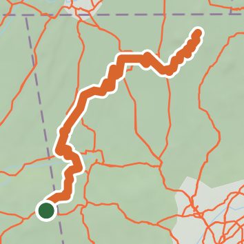
See the trail on the map, download it for offline use and record your hike. The iPhone and Android apps are on their way.
Before you go: trail information can be out of date or wrong, and a trail may be closed or on private land. Check current conditions with the land manager. You hike at your own risk. Full notice
On this hike
- Summits on this hike: Middle Mountain, Flagpole Mountain, Dug Mountain, Hurricane Mountain, Mill Creek Mountain, Turkey Mountain
- Lakes on this hike: Mountain End Lake
- Waterfalls on this hike: Keown Falls North 35, Keown Falls South 25
- Rivers and creeks on this hike: Baker Branch, Barnes Creek, Bear Creek, Cabin Creek, Conasauga Creek, Coon Creek, and 8 more
- Viewpoints on this hike: Johns Mountain Lookout Tower, 1 unnamed viewpoint
Elevation profile
Nearby trails
- Marshall Forest Hiking Trail1.4 mi · Easy · 12.5 mi away
- Lake Conasauga Footpath1.2 mi · Easy · 13.7 mi away
- Heritage Trail2.9 mi · Easy · 14.2 mi away
- AdventHealth ECO Greenway2.6 mi · Easy · 14.5 mi away