Great Circle Trail
Nahmakanta Public Reserved Land, Maine
27.9 miLength
3,270 ftElevation gain
StrenuousDifficulty
LoopRoute
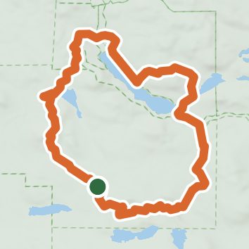
A loop of 27.9 mi in Nahmakanta Unit Ecological Reserve, Nahmakanta Public Reserved Land.
It gains 3,270 ft of elevation in all, between a low point of 600 ft and a high point of 1,860 ft about 24.6 mi in.
On the way it passes near Tumbledown Dick Falls, Hedgehog Pond, Rabbit Pond.
Described from the map and elevation data.
Open in Sahale GPS
See the trail on the map, download it for offline use and record your hike. The iPhone and Android apps are on their way.
Before you go: trail information can be out of date or wrong, and a trail may be closed or on private land. Check current conditions with the land manager. You hike at your own risk. Full notice
On this hike
- Summits on this hike: Wadleigh Mountain
- Lakes on this hike: Rabbit Pond, Leavitt Pond, Pollywog Pond, Wadleigh Pond, Nahmakanta Lake, Hedgehog Pond, and 6 more
- Waterfalls on this hike: Tumbledown Dick Falls
- Rivers and creeks on this hike: Pollywog Stream, Tumbledown Dick Stream
- Viewpoints on this hike: 2 unnamed viewpoints
Elevation profile
Low 600 ft27.9 miHigh 1,860 ft
Nearby trails
- tent site trail0.9 mi · Easy · 3.2 mi away
- lookout trail2 mi · Easy · 3.4 mi away
- Roach River Headwaters Trail1.2 mi · Easy · 5.8 mi away
- Shaw Mountain Cutoff1 mi · Easy · 6.9 mi away
- Lakeside Trail5.5 mi · Moderate · 7.5 mi away
- Emmit Brook Trail3.3 mi · Easy · 7.5 mi away
Camping nearby
- Campsite near sand beach5.8 mi from the trailhead
- Medawisla Lodge and Cabins7.6 mi from the trailhead
- West Branch Pond Camps9.8 mi from the trailhead
- HorseRace Campground11.7 mi from the trailhead