BCT 10
Massachusetts
39.9 miLength
2,320 ftElevation gain
StrenuousDifficulty
Out & BackRoute
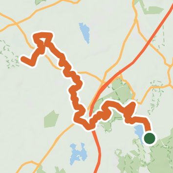
An out-and-back in Moose Hill Wildlife Sanctuary, 39.9 mi round trip.
It goes up and down rather than rising steadily: about 1,160 ft of elevation gain on the way out, between 140 ft and 530 ft, ending near Flynns Pond.
On the way it passes near Memorial Pond, Clark Pond, Diamond Pond.
The trailhead is in Sharon.
Described from the map and elevation data.
Open in Sahale GPS
See the trail on the map, download it for offline use and record your hike. The iPhone and Android apps are on their way.
Before you go: trail information can be out of date or wrong, and a trail may be closed or on private land. Check current conditions with the land manager. You hike at your own risk. Full notice
On this hike
- Summits on this hike: Pierce Hill, Moose Hill, Bluff Hill, Hobbs Hill
- Lakes on this hike: Memorial Pond, Clarks Pond Conservation Area, Lake Massapoag, Ganawatte Pond
- Rivers and creeks on this hike: Mine Brook, School Meadow Brook, Spring Brook
- Viewpoints on this hike: Bluff Overlook
Elevation profile
Low 140 ft39.9 miHigh 530 ft
Nearby trails
- Massapoag Trail0.7 mi · Easy · same trailhead
- Excercise Path0.4 mi · Easy · 0.3 mi away
- Massapoag Trail And Brook - Blue Dot0.5 mi · Easy · 0.5 mi away
- Path to Dog Park0.4 mi · Easy · 0.7 mi away
- Cottage Street School - Yellow Dot0.5 mi · Easy · 0.8 mi away
- Hobbs Hill Loop0.9 mi · Easy · 1.1 mi away
Camping nearby
- Missionary Point7.1 mi from the trailhead
- Ponkapoag Camp of Appalachian Mountain Club7.3 mi from the trailhead
- Spang Camp Site7.3 mi from the trailhead
- Normandy Farms Campground7.5 mi from the trailhead