Superior Hiking Trail
Minnesota
529.6 miLength
54,930 ftElevation gain
StrenuousDifficulty
Out & BackRoute
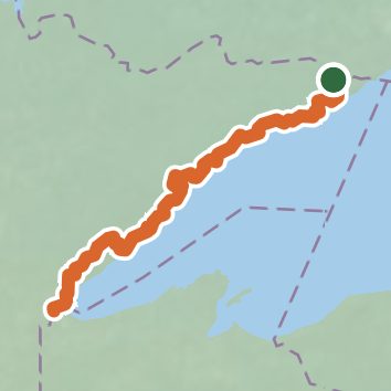
An out-and-back in Superior National Forest, 529.6 mi round trip.
It goes up and down rather than rising steadily: about 26,550 ft of elevation gain on the way out, between 610 ft and 1,830 ft, ending near Twin Lakes.
On the way it passes near Poplar River Falls, Devil's Kettle Falls, Barrier Falls.
Described from the map and elevation data.
Open in Sahale GPS
See the trail on the map, download it for offline use and record your hike. The iPhone and Android apps are on their way.
Before you go: trail information can be out of date or wrong, and a trail may be closed or on private land. Check current conditions with the land manager. You hike at your own risk. Full notice
On this hike
- Summits on this hike: Lookout Mountain
- Lakes on this hike: Lake Superior, Hartley Pond, Lake Agnes, Leveaux Pond, Egge Lake, Bally Creek Pond, and 5 more
- Waterfalls on this hike: Poplar River Falls, Devil's Kettle Falls, Barrier Falls, Devil's Kettle, High Falls, Upper Falls, Hidden Falls, Hidden Falls, 3 unnamed waterfalls
- Rivers and creeks on this hike: Beaver River, Big Sucker Creek, Brule River, Carlson Creek, Cascade River, Chester Creek, and 23 more
- Viewpoints on this hike: Sawmill Dome Overlook, 270-Degree Overlook, Split Rock, Blue Jay Overlook, Mount Trudee Overlook, Bear Lake Overlook, and 3 more, 20 unnamed viewpoints
Elevation profile
Low 610 ft534.6 miHigh 1,830 ft
Nearby trails
- Otter Lake Trail1.9 mi · Easy · 2.9 mi away
- Fowl Portage2.1 mi · Easy · 3.5 mi away
- Partridge Falls Portage0.7 mi · Easy · 4.2 mi away
- John - East Pike Portage1.3 mi · Easy · 8.8 mi away
- Moose Portage0.8 mi · Easy · 9.0 mi away
- West Pike - East Pike Portage9.8 mi · Hard · 9.3 mi away
Camping nearby
- Andy Creek1.5 mi from the trailhead
- Jackson Creek4.6 mi from the trailhead
- Caribou Pond6.2 mi from the trailhead
- North Carlson Pond6.5 mi from the trailhead