Wapack Trail
New Hampshire
An out-and-back in Wapack National Wildlife Refuge, 39.3 mi round trip.
It goes up and down rather than rising steadily: about 4,020 ft of elevation gain on the way out, between 1,210 ft and 1,920 ft.
The steepest stretch is between 11.1 mi and 11.6 mi from the trailhead, gaining 510 ft.
On the way it passes near Binney Pond.
The trailhead is about 2.9 mi north-west of New Ipswich in a straight line.
Described from the map and elevation data.
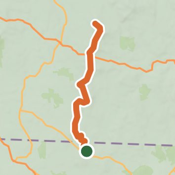
See the trail on the map, download it for offline use and record your hike. The iPhone and Android apps are on their way.
Before you go: trail information can be out of date or wrong, and a trail may be closed or on private land. Check current conditions with the land manager. You hike at your own risk. Full notice
On this hike
- Summits on this hike: Burton Peak, Pratt Mountain, Nutting Hill, North Pack Monadnock Mountain, New Ipswich Mountain, Stony Top, and 4 more
- Lakes on this hike: Binney Pond, Wildcat Pond
- Viewpoints on this hike: Roger Myrick Outlook, Currier Outlook, Pratt Mountain Viewpoint, 5 unnamed viewpoints
Elevation profile
Nearby trails
- Kidder Mountain trail -Blue triangle2.8 mi · Moderate · same trailhead
- Berry Pasture Trail1.8 mi · Moderate · 3.0 mi away
- Frank Robbins Trail2.3 mi · Easy · 4.1 mi away
- unnnamed path0.6 mi · Easy · 4.1 mi away
- Annett State Forest - Green Diamond0.5 mi · Easy · 4.1 mi away
- Green Pine1.7 mi · Easy · 4.2 mi away
Camping nearby
- Woodland Camp3.5 mi from the trailhead
- Woodmere Campground6.3 mi from the trailhead
- Damon Pond Campground9.7 mi from the trailhead
- CIT Village10.2 mi from the trailhead