NJ State Long Trail
Pinelands National Reserve, New Jersey
A one-way trail of 241.2 mi in Delaware and Raritan Canal State Park, Pinelands National Reserve.
It goes up and down rather than rising steadily: about 2,530 ft of elevation gain along the way, between 0 ft and 310 ft.
On the way it passes near Daveys Lake, Lake Lily, Lighthouse Pond.
The trailhead is about 2.6 mi south of North Cape May in a straight line.
Described from the map and elevation data.
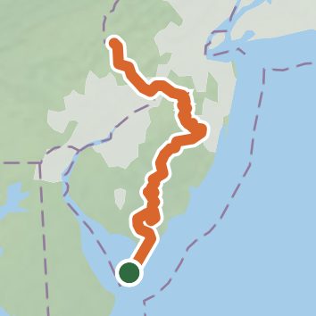
See the trail on the map, download it for offline use and record your hike. The iPhone and Android apps are on their way.
Before you go: trail information can be out of date or wrong, and a trail may be closed or on private land. Check current conditions with the land manager. You hike at your own risk. Full notice
On this hike
- Summits on this hike: Apple Pie Hill
- Lakes on this hike: Mercer Lake, Batsto Lake, Lake Lenape, Daveys Lake, Lake Nescochague, Lake Nummy, and 11 more
- Rivers and creeks on this hike: Assunpink Creek, Batsto River, Bradley Run, Ivanhoe Brook, Lahaway Creek, Skit Branch
- Viewpoints on this hike: 5 unnamed viewpoints
Elevation profile
Nearby trails
- Cape May Point State Park - Red Trail0.5 mi · Easy · 0.9 mi away
- Cape May Point State Park - Yellow Trail2.2 mi · Easy · 0.9 mi away
- Cape May Point State Park - Blue Trail2.9 mi · Easy · 0.9 mi away
- Cattail Trail0.4 mi · Easy · 1.0 mi away
- State Park Connection Trail1.2 mi · Easy · 1.2 mi away
- Dune Trail1 mi · Easy · 1.2 mi away
Camping nearby
- The Depot Travel Park1.8 mi from the trailhead
- Cape Island Resort3.8 mi from the trailhead
- Seashore Campsites RV Park & Campground4.1 mi from the trailhead
- King Nummy Trail Camoground10.0 mi from the trailhead