Appalachian Trail
New York
A one-way trail of 154 mi in Appalachian National Scenic Trail, Clarence Fahnestock Memorial State Park.
It goes up and down rather than rising steadily: about 28,610 ft of elevation gain along the way, between -0 ft and 1,700 ft, ending near Quaker Lake.
The steepest stretch is between 60.1 mi and 60.6 mi from the trailhead, gaining 550 ft.
On the way it passes near Dunnfield Creek Falls, Little Dam Lake, Sunfish Pond.
The trailhead is about 3 mi south-east of East Stroudsburg in a straight line.
Described from the map and elevation data.
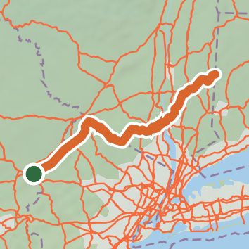
See the trail on the map, download it for offline use and record your hike. The iPhone and Android apps are on their way.
Before you go: trail information can be out of date or wrong, and a trail may be closed or on private land. Check current conditions with the land manager. You hike at your own risk. Full notice
On this hike
- Summits on this hike: Fingerboard Mountain, Sunrise Mountain, Mount Egbert, Mount Mohican, Island Pond Mountain, Blue Mountain, and 7 more
- Lakes on this hike: Sunfish Pond, Nuclear Lake, Copperhead Spring Pond, Hessian Lake, Little Dam Lake, Parker Lake, and 2 more
- Waterfalls on this hike: Dunnfield Creek Falls, 1 unnamed waterfall
- Rivers and creeks on this hike: Dunnfield Creek, Surebridge Brook
- Viewpoints on this hike: Lemon squeezer rock gap, Sunrise Mountain Pavillon, view south, lake, beach, Mount Mohican, Scenic Overlook - Delaware River and Reservoir, Large Pile of Rocks, and 6 more, 40 unnamed viewpoints
Elevation profile
Camping nearby
- Backpacker Campsite 22.9 mi from the trailhead
- Hickory Lake Campground3.3 mi from the trailhead
- Camp OUT Campground3.4 mi from the trailhead
- Worthington State Forest Campground3.6 mi from the trailhead