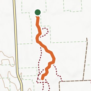
Chateaugay State Forest - Trail 3
Chateaugay State Forest, New York
2.6 miLength
110 ftElevation gain
EasyDifficulty
Out & BackRoute
An out-and-back in Chateaugay State Forest, 2.6 mi round trip.
It is gentle the whole way, staying between 1,060 ft and 1,110 ft.
The trailhead is about 4.7 mi north-east of Richland in a straight line.
Described from the map and elevation data.
Open in Sahale GPS
See the trail on the map, download it for offline use and record your hike. The iPhone and Android apps are on their way.
Before you go: trail information can be out of date or wrong, and a trail may be closed or on private land. Check current conditions with the land manager. You hike at your own risk. Full notice
Elevation profile
Low 1,060 ft2.6 miHigh 1,110 ft
Nearby trails
- Chateaugay State Forest - Trail 61.4 mi · Easy · same trailhead
- Chateaugay State Forest - Trail 22.6 mi · Easy · same trailhead
- Chateaugay State Forest - Trail 13.6 mi · Easy · same trailhead
- Chateaugay State Forest - Trail 42 mi · Easy · 1.8 mi away
- Chateaugay State Forest - Trail 51.5 mi · Easy · 1.8 mi away
- Old Hobbit & Elf Trail5.3 mi · Easy · 1.8 mi away
Camping nearby
- Brennan Beach Campground11.8 mi from the trailhead
- Bears Sleepy Hollow12.1 mi from the trailhead
- Acorn Loop12.5 mi from the trailhead
- Dragonfly Loop12.6 mi from the trailhead