Long Path
New York
An out-and-back in Slide Mountain Wilderness, Catskill Park, 345.8 mi round trip.
It goes up and down rather than rising steadily: about 45,360 ft of elevation gain on the way out, between 250 ft and 4,180 ft, ending near Orange-Rockland Lake.
The steepest stretch is between 107.3 mi and 107.8 mi from the trailhead, gaining 950 ft.
On the way it passes near Wildcat Falls, Buttermilk Falls, Old Mill Falls.
The trailhead is about 11.4 mi north of Wawarsing in a straight line.
Described from the map and elevation data.
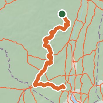
See the trail on the map, download it for offline use and record your hike. The iPhone and Android apps are on their way.
Before you go: trail information can be out of date or wrong, and a trail may be closed or on private land. Check current conditions with the land manager. You hike at your own risk. Full notice
On this hike
- Summits on this hike: Blackhead, Table Mountain, Silver Hollow Notch Mountain, High Point, Slide Mountain, Wittenberg Mountain, and 14 more
- Lakes on this hike: Orange Rockland Lakes, diked marshy impoundment, Lyon Lake
- Waterfalls on this hike: Wildcat Falls, Buttermilk Falls, Old Mill Falls, Verkeerderkill Falls, Viola Falls, Vernooy Kill Falls, Plattekill Falls, Hells Hole Falls, Upper Hell Hole Falls, Elizabeth Falls, 2 unnamed waterfalls
- Rivers and creeks on this hike: Catlin Creek, Esopus Creek, Kaaterskill Creek, Mine Hole Brook, Mombaccus Creek, Rondout Creek, and 3 more
- Viewpoints on this hike: Twin Mountain south summit, Camp Steel overlook, Newmans Ledge, Old Fire Tower Viewpoint, Artists Rock, Boulder Rock, and 12 more, 64 unnamed viewpoints
Elevation profile
Nearby trails
- Table-Lone Herd Path9.4 mi · Strenuous · 3.7 mi away
- Finger Lakes Trail (Catskill Region)364.3 mi · Strenuous · 3.7 mi away
- Fishermen's Path8.4 mi · Hard · 3.7 mi away
- Fisherman's Path - Lone Herd Path7.5 mi · Hard · 3.7 mi away
- Denman Mountain Trail5.6 mi · Moderate · 4.9 mi away
- Red Hill Fire Tower Trail3.6 mi · Moderate · 5.3 mi away
Camping nearby
- Primitive Campsite5.5 mi from the trailhead
- Sequoia Village6.6 mi from the trailhead
- Trips Village6.7 mi from the trailhead
- Putnam Village6.7 mi from the trailhead