Bartram Trail
Nantahala National Forest, North Carolina
An out-and-back in Nantahala National Forest, 133.9 mi round trip.
It goes up and down rather than rising steadily: about 17,910 ft of elevation gain on the way out, between 2,020 ft and 5,340 ft, ending near Cheoah Bald.
The steepest stretch is between 13.9 mi and 14.4 mi from the trailhead, gaining 520 ft.
On the way it passes near Bartram Falls, Ray Cove Falls, The Notch.
The trailhead is about 2.9 mi west of Franklin in a straight line.
Described from the map and elevation data.
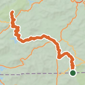
See the trail on the map, download it for offline use and record your hike. The iPhone and Android apps are on their way.
Before you go: trail information can be out of date or wrong, and a trail may be closed or on private land. Check current conditions with the land manager. You hike at your own risk. Full notice
On this hike
- Summits on this hike: Wayah Bald, Cheoah Bald, Little Fishhawk Mountain
- Lakes on this hike: Nantahala Lake
- Waterfalls on this hike: Bartram Falls, Ray Cove Falls, The Notch
- Rivers and creeks on this hike: Ledbetter Creek, McDowell Branch, Nantahala River, Wallace Branch, Wine Spring Creek
- Viewpoints on this hike: Wayah Bald Fire Tower, William's Pulpit, 1 unnamed viewpoint
Elevation profile
Nearby trails
- Rufus Morgan Trail1 mi · Easy · 6.9 mi away
- Wasilik Poplar Trail1.2 mi · Easy · 7.8 mi away
- Buckeye Creek Trail4 mi · Moderate · 8.4 mi away
- Siler Bald Shelter Trail4.7 mi · Hard · 8.5 mi away
- Siler Bald Vista Trail2.8 mi · Moderate · 8.5 mi away
- Wilson Lick Trail0.3 mi · Easy · 8.6 mi away
Camping nearby
- Rose Creek Campground4.3 mi from the trailhead
- Winding Stair Campground8.5 mi from the trailhead
- Standing Indian Campground9.0 mi from the trailhead
- Kimsey Creek Group Camp Site A9.4 mi from the trailhead