Lost Cove Loop Trail
Lost Cove Wilderness Study Area, North Carolina
A loop of 8.1 mi in Lost Cove Wilderness Study Area, Pisgah National Forest.
It gains 1,450 ft of elevation in all, between a low point of 1,700 ft and a high point of 2,950 ft about 2.1 mi in.
On the way it passes near Huntfish Sidekick Falls, Gragg Prong Falls, Huntfish Falls.
The trailhead is about 14.7 mi south-west of Boone in a straight line.
Described from the map and elevation data.
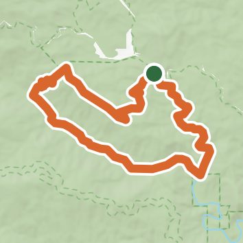
See the trail on the map, download it for offline use and record your hike. The iPhone and Android apps are on their way.
Before you go: trail information can be out of date or wrong, and a trail may be closed or on private land. Check current conditions with the land manager. You hike at your own risk. Full notice
On this hike
- Summits on this hike: Bee Mountain
- Waterfalls on this hike: Huntfish Sidekick Falls, Middle Gragg Prong Falls, Huntfish Falls, Gragg Prong Falls, Upper Gragg Prong Falls, Little Lost Cove Falls
- Rivers and creeks on this hike: Gragg Prong, Lost Cove Creek
Elevation profile
Nearby trails
- Timber Ridge Trail5.2 mi · Hard · same trailhead
- Marks Mountain Trail6.9 mi · Hard · 0.6 mi away
- Dark Side Cliffs Trail1 mi · Easy · 1.8 mi away
- Yancey Ridge Trail13.4 mi · Strenuous · 1.9 mi away
- Old Yancey Ridge2.6 mi · Moderate · 1.9 mi away
- Little Lost Cove Cliffs Trail2.6 mi · Moderate · 1.9 mi away
Camping nearby
- Mortimer Campground3.7 mi from the trailhead
- Down by the River Campground5.1 mi from the trailhead
- Pineola Inn Campground5.3 mi from the trailhead
- Grandfather Campground7.6 mi from the trailhead