ADT - Ohio D - Seg 4
Ohio
52.4 miLength
5,460 ftElevation gain
StrenuousDifficulty
Point to PointRoute
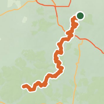
A one-way trail of 52.4 mi in Hocking State Forest.
It goes up and down rather than rising steadily: about 5,820 ft of elevation gain along the way, between 630 ft and 1,090 ft.
On the way it passes near Devil's Bathtub, Falls, Ash Cave.
The trailhead is about 2.4 mi south of Geneva in a straight line.
Described from the map and elevation data.
Open in Sahale GPS
See the trail on the map, download it for offline use and record your hike. The iPhone and Android apps are on their way.
Before you go: trail information can be out of date or wrong, and a trail may be closed or on private land. Check current conditions with the land manager. You hike at your own risk. Full notice
On this hike
- Lakes on this hike: Lake Logan
- Waterfalls on this hike: Devil's Bathtub, Upper Falls, Ash Cave, Lower Falls, Whispering Falls, Cedar Falls, Broken Rock Falls
- Rivers and creeks on this hike: Duck Creek, Old Man's Creek, Queer Creek
- Viewpoints on this hike: Lower Falls Lookout, 1 unnamed viewpoint
Elevation profile
Low 630 ft52.4 miHigh 1,090 ft
Nearby trails
- Buckeye Trail (Old Mans Cave)52.7 mi · Strenuous · same trailhead
- North Trailhead0.5 mi · Easy · 0.8 mi away
- Boch Hollow State Nature Preserve - Meadow Trail1.4 mi · Easy · 1.4 mi away
- Natural Bridge Loop Trail1.6 mi · Easy · 5.5 mi away
- Rock Shelter Trail1.7 mi · Easy · 5.5 mi away
- Tree Identification Trail0.4 mi · Easy · 6.4 mi away
Camping nearby
- Geneva Hills8.2 mi from the trailhead
- Creekside Campground9.8 mi from the trailhead
- Williams Campground10.7 mi from the trailhead
- Begley's ATV Campground11.1 mi from the trailhead