Buckeye Trail
Ohio
1,406.7 miLength
90,770 ftElevation gain
StrenuousDifficulty
Point to PointRoute
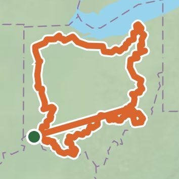
Open in Sahale GPS
See the trail on the map, download it for offline use and record your hike. The iPhone and Android apps are on their way.
Before you go: trail information can be out of date or wrong, and a trail may be closed or on private land. Check current conditions with the land manager. You hike at your own risk. Full notice
On this hike
- Summits on this hike: Bell Hill, Dodd Hill
- Lakes on this hike: Burr Oak Reservoir, Caesar Creek Lake, Camp Crowell Lake, Camp Hilaka Lake, Clendening Lake, Comet Lake, and 43 more
- Waterfalls on this hike: Bridal Veil Falls, Devil's Bathtub, Lower Falls, Deer Lick Cave Falls, Ash Cave, Whispering Falls, Upper Falls, Cedar Falls, Broken Rock Falls, 2 unnamed waterfalls
- Rivers and creeks on this hike: Archers Fork, Barnes Run, Big Creek, Buffalo Creek, Caesar Creek, Cedar Creek, and 40 more
- Viewpoints on this hike: Bird Viewing at Indianola Overlook, Linda Falls, Lower Falls Lookout, Bridal Veil Falls Overlook, Gorge Overlook, Floods Point Overlook, and 1 more, 8 unnamed viewpoints
Elevation profile
Low 500 ft1,406.7 miHigh 1,330 ft
Nearby trails
- Buckeye Trail (Loveland)46.2 mi · Strenuous · same trailhead
- ADT - Ohio D - Seg 1026.9 mi · Strenuous · same trailhead
- The Friends Bracelet Paths: Path of Man0.7 mi · Easy · 0.7 mi away
- The Friends Bracelet Paths: Path of Nature0.6 mi · Easy · 0.7 mi away
- Geologic Timeline0.6 mi · Easy · 1.3 mi away
- Ransohoff Overlook Trail1.1 mi · Easy · 1.6 mi away
Camping nearby
- Dan Beard Reservation13.1 mi from the trailhead
- River Days Campground14.5 mi from the trailhead