Buckeye Trail (Akron)
Ohio
57.4 miLength
2,730 ftElevation gain
StrenuousDifficulty
Point to PointRoute
A one-way trail of 57.4 mi in Cuyahoga Valley National Park.
It goes up and down rather than rising steadily: about 2,760 ft of elevation gain along the way, between 640 ft and 1,020 ft.
On the way it passes near Deer Lick Cave Falls, Blue Hen Falls, Summit Lake.
The trailhead is about 1.3 mi south-east of Brecksville in a straight line.
Described from the map and elevation data.
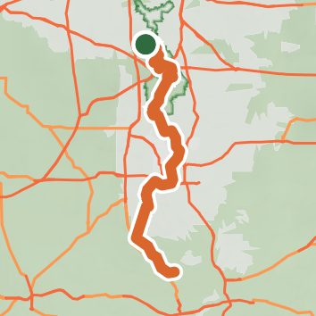
Open in Sahale GPS
See the trail on the map, download it for offline use and record your hike. The iPhone and Android apps are on their way.
Before you go: trail information can be out of date or wrong, and a trail may be closed or on private land. Check current conditions with the land manager. You hike at your own risk. Full notice
On this hike
- Lakes on this hike: Summit Lake, Lake Lucern, Lake Nesmith
- Waterfalls on this hike: Deer Lick Cave Falls, Blue Hen Falls, 4 unnamed waterfalls
- Rivers and creeks on this hike: Boston Run, Cuyahoga River, Tuscarawas River, Little Cuyahoga River
- Viewpoints on this hike: 1 unnamed viewpoint
Elevation profile
Low 640 ft57.3 miHigh 1,020 ft
Nearby trails
- Buckeye Trail (Bedford)66.9 mi · Strenuous · same trailhead
- East Bridal Trail1.9 mi · Easy · same trailhead
- West Bridal Trail0.3 mi · Easy · same trailhead
- South Bridle Loop1.4 mi · Easy · 0.4 mi away
- Oak Grove All Purpose Trail Loop0.5 mi · Easy · 0.4 mi away
- North Bridle Loop0.7 mi · Easy · 0.4 mi away
Camping nearby
- Camp Manatoc6.8 mi from the trailhead
- Valley Overlook at Camp Mueller7.6 mi from the trailhead
- Hiram House Camp13.0 mi from the trailhead
- Stow Silver Springs Campground13.1 mi from the trailhead