Buckeye Trail (Mogadore)
Ohio
74.4 miLength
2,920 ftElevation gain
StrenuousDifficulty
Point to PointRoute
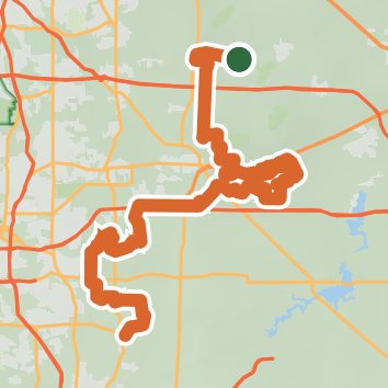
A one-way trail of 74.4 mi in West Branch State Park.
It goes up and down rather than rising steadily: about 2,950 ft of elevation gain along the way, between 980 ft and 1,280 ft.
The trailhead is about 3.4 mi west of Garrettsville in a straight line.
Described from the map and elevation data.
Open in Sahale GPS
See the trail on the map, download it for offline use and record your hike. The iPhone and Android apps are on their way.
Before you go: trail information can be out of date or wrong, and a trail may be closed or on private land. Check current conditions with the land manager. You hike at your own risk. Full notice
On this hike
- Lakes on this hike: Hills Pond, Michael J Kirwan Reservoir, Mogadore Reservoir, Wingfoot Lake
- Rivers and creeks on this hike: Cuyahoga River, West Branch Mahoning River
Elevation profile
Low 980 ft74.3 miHigh 1,280 ft
Nearby trails
- Oak Ridge Trail0.7 mi · Easy · 2.1 mi away
- Grand Oaks Trail1.5 mi · Easy · 2.8 mi away
- James H. Barrow Biological Field Station - Main Trail9 mi · Hard · 2.9 mi away
- Headwaters Trail5.8 mi · Easy · 3.4 mi away
- Tom Collins Memorial Rotary Trail0.4 mi · Easy · 3.5 mi away
- Glacial Esker Trail1.3 mi · Easy · 3.6 mi away
Camping nearby
- Roundup Lake Campground6.0 mi from the trailhead
- Tucaway Lake Campground7.7 mi from the trailhead
- Kool Lakes Family Campground7.9 mi from the trailhead
- Hidden Valley Campground8.1 mi from the trailhead