PCT - Oregon Section C
Sky Lakes Wilderness, Oregon
A one-way trail of 73.8 mi in Sky Lakes Wilderness, Crater Lake National Park.
It goes up and down rather than rising steadily: about 7,400 ft of elevation gain along the way, between 4,970 ft and 7,360 ft, ending near Freye Lake.
The steepest stretch is between 48.6 mi and 49.1 mi from the trailhead, gaining 400 ft.
On the way it passes near Mirror Pond, Fly Lake, Center Lake.
There are 2 campgrounds within 2 mi of the trailhead; the nearest is hiker/biker camp.
Described from the map and elevation data.
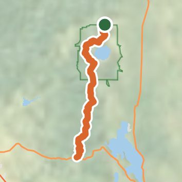
See the trail on the map, download it for offline use and record your hike. The iPhone and Android apps are on their way.
Before you go: trail information can be out of date or wrong, and a trail may be closed or on private land. Check current conditions with the land manager. You hike at your own risk. Full notice
On this hike
- Summits on this hike: Shale Butte
Elevation profile
Nearby trails
- Union Peak Trail9.5 mi · Hard · same trailhead
- Annie Creek Trail1.6 mi · Easy · 0.9 mi away
- Godfrey Glen Trail1.1 mi · Easy · 1.8 mi away
- Castle Crest Trail0.8 mi · Easy · 2.8 mi away
- Pumice Flat Trail11.9 mi · Hard · 2.9 mi away
- Lady of the Woods Trail0.7 mi · Easy · 3.0 mi away
Camping nearby
- hiker/biker camp1.0 mi from the trailhead
- Mazama Campground1.0 mi from the trailhead
- Lightning Springs Backcountry Campsite4.3 mi from the trailhead
- Lost Creek Campground7.2 mi from the trailhead