Appalachian Trail
Pennsylvania
224.6 miLength
30,430 ftElevation gain
StrenuousDifficulty
Point to PointRoute
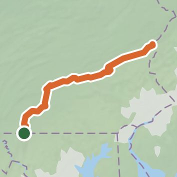
A one-way trail of 224.6 mi in Michaux State Forest.
It goes up and down rather than rising steadily: about 29,260 ft of elevation gain along the way, between 290 ft and 2,080 ft.
The steepest stretch is between 189.2 mi and 189.7 mi from the trailhead, gaining 610 ft.
On the way it passes near Fuller Lake.
The trailhead is about 4.5 mi south-east of Waynesboro in a straight line.
Described from the map and elevation data.
Open in Sahale GPS
See the trail on the map, download it for offline use and record your hike. The iPhone and Android apps are on their way.
Before you go: trail information can be out of date or wrong, and a trail may be closed or on private land. Check current conditions with the land manager. You hike at your own risk. Full notice
On this hike
- Summits on this hike: Mount Minsi, Dans Pulpit, Pulpit Rock, Bake Oven Knob, Rocky Mountain, Bears Rocks, and 1 more
- Lakes on this hike: Children's Lake, Lenape Lake, Fuller Lake
- Rivers and creeks on this hike: Conocheague Creek, Conodoguinet Creek, Mountain Creek, Quarry Run, Tom's Run, Tumbling Run
- Viewpoints on this hike: Hawk Rock, Long Beaver Dam, Kimmel Lookout, Eureka Creek, Hawk Rock Overlook, Minsi Lookout, and 8 more, 20 unnamed viewpoints
Elevation profile
Low 290 ft224.6 miHigh 2,080 ft
Nearby trails
- Paul Benchoff Memorial Overlook Trail1.8 mi · Easy · 1.7 mi away
- Fox Crossing Trail1.4 mi · Easy · 1.8 mi away
- Washington Township Boulevard Trail4.5 mi · Easy · 1.9 mi away
- Monterey Peak Trail1.3 mi · Easy · 2.0 mi away
- North Peak Trail1.7 mi · Easy · 2.0 mi away
- Deer Trail1.1 mi · Easy · 2.0 mi away
Camping nearby
- Adirondack Shelters Camping Area3.1 mi from the trailhead
- Owens Creek Campground4.3 mi from the trailhead
- Poplar Grove Youth Group Campground5.0 mi from the trailhead
- Camp Round Meadow5.3 mi from the trailhead