Log Slide Trail
Tiadaghton State Forest, Pennsylvania
2.5 miLength
1,070 ftElevation gain
ModerateDifficulty
Out & BackRoute
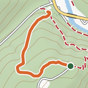
An out-and-back in Tiadaghton State Forest, 2.5 mi round trip.
It goes downhill first, dropping 1,080 ft to 740 ft, so the elevation gain is on the way back.
The trailhead is about 9.3 mi north-west of Jersey Shore in a straight line.
Described from the map and elevation data.
Open in Sahale GPS
See the trail on the map, download it for offline use and record your hike. The iPhone and Android apps are on their way.
Before you go: trail information can be out of date or wrong, and a trail may be closed or on private land. Check current conditions with the land manager. You hike at your own risk. Full notice
On this hike
- Viewpoints on this hike: 1 unnamed viewpoint
Elevation profile
Low 740 ft2.5 miHigh 1,830 ft
Nearby trails
- Tiadaghton Trail11.1 mi · Strenuous · 0.4 mi away
- Old Wagon Trail8 mi · Hard · 0.5 mi away
- Eiger Trail2.6 mi · Moderate · 0.6 mi away
- Tiadaghton Trail8.7 mi · Strenuous · 0.6 mi away
- Tower Trail4.3 mi · Hard · 0.6 mi away
- Wolf Path1.4 mi · Easy · 0.8 mi away
Camping nearby
- Happy Acres Resort3.1 mi from the trailhead
- Little Pine State Park3.5 mi from the trailhead
- Bonnell Flats3.6 mi from the trailhead
- Black Walnut Bottom12.1 mi from the trailhead