Lower Hornbecks Trail
Delaware Water Gap National Recreation Area, Pennsylvania
2.2 miLength
130 ftElevation gain
EasyDifficulty
Out & BackRoute
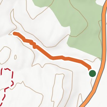
An out-and-back in Pennsylvania, 2.2 mi round trip.
It is gentle the whole way, staying between 380 ft and 490 ft and ending near Indian Ladder Falls.
The trailhead is about 6.2 mi north-east of Pine Ridge in a straight line.
Dingmans Campground is within 2 mi of the trailhead.
Described from the map and elevation data.
Open in Sahale GPS
See the trail on the map, download it for offline use and record your hike. The iPhone and Android apps are on their way.
Before you go: trail information can be out of date or wrong, and a trail may be closed or on private land. Check current conditions with the land manager. You hike at your own risk. Full notice
On this hike
- Waterfalls on this hike: Lower Indian Ladder Falls
- Rivers and creeks on this hike: Deckers Creek
Elevation profile
Low 380 ft2.2 miHigh 490 ft
Nearby trails
- Hornbecks Creek Trail0.6 mi · Easy · 1.3 mi away
- Campground Trail0.4 mi · Easy · 1.7 mi away
- Fossil Trail1.8 mi · Easy · 1.7 mi away
- Two Ponds Trail1.6 mi · Easy · 1.9 mi away
- Ridgeline Trail6.7 mi · Hard · 1.9 mi away
- Scenic Gorge Trail2.9 mi · Moderate · 1.9 mi away
Camping nearby
- Dingmans Campground1.6 mi from the trailhead
- Bear Creek Campgrounds2.9 mi from the trailhead
- Shotwell Camping Area4.8 mi from the trailhead
- Haskin's Group Camping Area5.5 mi from the trailhead