Mid-State Trail
Pennsylvania
An out-and-back in State Game Lands Number 73, Rothrock State Forest, 433.2 mi round trip.
It goes up and down rather than rising steadily: about 39,100 ft of elevation gain on the way out, between 530 ft and 2,420 ft, ending near Big Pond.
The steepest stretch is between 103.2 mi and 103.7 mi from the trailhead, gaining 680 ft.
On the way it passes near Beaver Pond, Halfway Lake.
The trailhead is about 9.5 mi south-east of State College in a straight line.
Described from the map and elevation data.
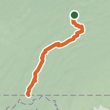
See the trail on the map, download it for offline use and record your hike. The iPhone and Android apps are on their way.
Before you go: trail information can be out of date or wrong, and a trail may be closed or on private land. Check current conditions with the land manager. You hike at your own risk. Full notice
On this hike
- Summits on this hike: Bald Mountain, Round Top, Bake Oven Mountain, Long Mtn Peak
- Lakes on this hike: Half Way Lake
- Rivers and creeks on this hike: Big Poe Creek, Cherry Run, Detweiler Run, Frankstown Branch Juniata River, Gamble Run, Greens Valley Stream, and 10 more
- Viewpoints on this hike: Indian Wells Vista, Ramm Road Vista, Hubler Gap Vista, Laurel Run Vista, Harry's Valley Vista, 8 unnamed viewpoints
Elevation profile
Nearby trails
- Broad Mountain West Loop Trail2.6 mi · Easy · same trailhead
- Logging Railroad Grade3 mi · Easy · 1.8 mi away
- Shale Pit Trail2.5 mi · Easy · 2.0 mi away
- Indian Trail3 mi · Moderate · 2.0 mi away
- Reichley Trail0.5 mi · Easy · 2.1 mi away
- Brush Ridge Trail1.3 mi · Easy · 2.2 mi away
Camping nearby
- 004 Bear Meadows Road2.8 mi from the trailhead
- Rothrock Campsite 63.3 mi from the trailhead
- 005 Crowfield Road3.4 mi from the trailhead
- Aikens Cabins at Bear Meadows4.1 mi from the trailhead