Boulevard Trail
Great Smoky Mountains National Park, Tennessee
7.9 miLength
2,530 ftElevation gain
StrenuousDifficulty
Point to PointRoute
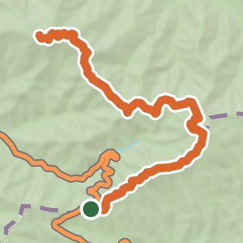
Open in Sahale GPS
See the trail on the map, download it for offline use and record your hike. The iPhone and Android apps are on their way.
Before you go: trail information can be out of date or wrong, and a trail may be closed or on private land. Check current conditions with the land manager. You hike at your own risk. Full notice
On this hike
- Summits on this hike: Mount Le Conte, Mount le Conte - High Top, Mount Ambler
- Viewpoints on this hike: Newfound Gap Overlook
Elevation profile
Low 5,040 ft7.9 miHigh 6,590 ft
Nearby trails
- Cliff Top Trail10.8 mi · Strenuous · 1.9 mi away
- Cliif Top Trail10.3 mi · Strenuous · 1.9 mi away
- Bull Head Trail11.3 mi · Strenuous · 1.9 mi away
- Alum Cave Trail4.9 mi · Hard · 1.9 mi away
- Chimney Tops Trail1.8 mi · Moderate · 3.0 mi away
- Cove Hardwood Nature Trail0.8 mi · Easy · 4.2 mi away
Camping nearby
- Smokemont Group Camp7.2 mi from the trailhead
- Smokemont Campground7.4 mi from the trailhead
- Gatlinburg Creekside RV Resort8.3 mi from the trailhead
- Twin Creek RV Resort8.5 mi from the trailhead