Cumberland Trail
North Cumberland Wildlife Management Area, Tennessee
37 miLength
8,850 ftElevation gain
StrenuousDifficulty
Point to PointRoute
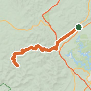
A one-way trail of 37 mi in Tennessee.
It goes up and down rather than rising steadily: about 9,460 ft of elevation gain along the way, between 1,040 ft and 3,020 ft.
The steepest stretch is between 13.8 mi and 14.3 mi from the trailhead, gaining 560 ft.
The trailhead is in LaFollette.
Described from the map and elevation data.
Open in Sahale GPS
See the trail on the map, download it for offline use and record your hike. The iPhone and Android apps are on their way.
Before you go: trail information can be out of date or wrong, and a trail may be closed or on private land. Check current conditions with the land manager. You hike at your own risk. Full notice
On this hike
- Summits on this hike: Eagle Bluff
- Viewpoints on this hike: Eagle Bluff
Elevation profile
Low 1,040 ft37 miHigh 3,020 ft
Nearby trails
- Woodson Gap Connector3.2 mi · Moderate · 7.0 mi away
- Beaver Creek Workshop Trail1 mi · Easy · 7.9 mi away
- Volunteer Loop Trail1.5 mi · Easy · 7.9 mi away
- Hootin Hollow Trail2.2 mi · Easy · 10.0 mi away
- Marine Railway Trail1.6 mi · Easy · 10.1 mi away
- Elkins Trail2.2 mi · Easy · 10.1 mi away
Camping nearby
- Stinking Creek ATV Campground7.3 mi from the trailhead
- West Campground10.1 mi from the trailhead
- Coal Creek Campground11.2 mi from the trailhead
- East Campground11.8 mi from the trailhead