Fiery Gizzard Trail
Tennessee
A one-way trail of 11.7 mi in Tennessee.
It goes up and down rather than rising steadily: about 1,840 ft of elevation gain along the way, between 1,310 ft and 1,850 ft, ending near Horsehair Falls 80.
The steepest stretch is between 3.5 mi and 4 mi from the trailhead, gaining 400 ft.
On the way it passes near Black Canyon Falls, Chain Falls, Blue Hole Falls.
The trailhead is about 10.4 mi east of Sewanee in a straight line.
Described from the map and elevation data.
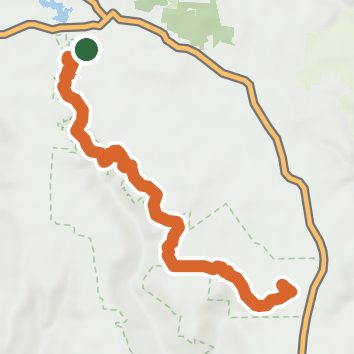
See the trail on the map, download it for offline use and record your hike. The iPhone and Android apps are on their way.
Before you go: trail information can be out of date or wrong, and a trail may be closed or on private land. Check current conditions with the land manager. You hike at your own risk. Full notice
On this hike
- Waterfalls on this hike: Black Canyon Falls, Chain Falls, Horsehair Falls 80, Blue Hole Falls, Ester Falls, Anderson Falls, Foster Falls 60, Small Waterfall, Sycamore Falls, 3 unnamed waterfalls
- Rivers and creeks on this hike: Little Fiery Gizzard Creek, Big Fiery Gizzard Creek
- Viewpoints on this hike: Foster Falls Overlook, FIery Gizzard Trail Overlook, Foster Falls Main Overlook, 3 unnamed viewpoints
Elevation profile
Nearby trails
- Grundy Forest Day Loop1.9 mi · Easy · same trailhead
- Dog Hole Trail5 mi · Moderate · 0.5 mi away
- Ravens Point Spur Trail3 mi · Easy · 1.4 mi away
- Little Cove Camp Spur9.9 mi · Hard · 6.4 mi away
- Climbers Loop Trail1.8 mi · Easy · 6.4 mi away
- Piney Point1.7 mi · Easy · 8.9 mi away
Camping nearby
- Foster Falls Campground Host6.4 mi from the trailhead
- Foster Falls Campground6.5 mi from the trailhead
- Caver's Paradise10.6 mi from the trailhead
- Greeter Falls Campground13.4 mi from the trailhead