Arsens Garden Loop Trail
San Rafael Swell Recreation Area, Utah
15.3 miLength
740 ftElevation gain
HardDifficulty
Out & BackRoute
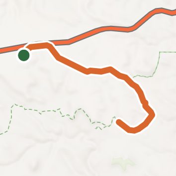
An out-and-back in San Rafael Swell Recreation Area, 15.3 mi round trip.
It goes downhill first, dropping 330 ft to 6,410 ft, so the elevation gain is on the way back.
Described from the map and elevation data.
Open in Sahale GPS
See the trail on the map, download it for offline use and record your hike. The iPhone and Android apps are on their way.
Before you go: trail information can be out of date or wrong, and a trail may be closed or on private land. Check current conditions with the land manager. You hike at your own risk. Full notice
Elevation profile
Low 6,370 ft15.3 miHigh 6,770 ft
Nearby trails
- Grease Point trail13.1 mi · Hard · same trailhead
- Escape Route (BLM 835)9 mi · Hard · 7.5 mi away
- Swasey's Leap Trail9.4 mi · Hard · 8.2 mi away
- Lower Black Box Trail3.9 mi · Moderate · 8.2 mi away
- Sids Leap Trail4.6 mi · Moderate · 8.5 mi away
- Five Miles of Hell (BLM 839)22.9 mi · Strenuous · 9.7 mi away
Camping nearby
- San Rafael Swinging Bridge Campground13.2 mi from the trailhead
- Equestrian Campground13.2 mi from the trailhead
- Swinging Bridge North Campground13.4 mi from the trailhead
- Buckhorn Draw Campsite 3314.4 mi from the trailhead