Great Western Trail - Utah
Utah
An out-and-back in Manti-La Sal National Forest, Dixie National Forest, 1,127.2 mi round trip.
It goes up and down rather than rising steadily: about 69,460 ft of elevation gain on the way out, between 5,010 ft and 11,150 ft, ending near Bald Mountain.
The steepest stretch is between 194.2 mi and 194.7 mi from the trailhead, gaining 380 ft.
On the way it passes near Farmington Lake, Black Lake, Horse Lake.
The trailhead is about 19.7 mi east of Kanab in a straight line.
Described from the map and elevation data.
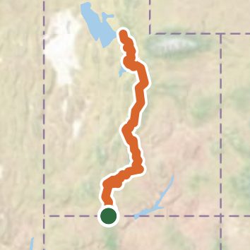
See the trail on the map, download it for offline use and record your hike. The iPhone and Android apps are on their way.
Before you go: trail information can be out of date or wrong, and a trail may be closed or on private land. Check current conditions with the land manager. You hike at your own risk. Full notice
On this hike
- Summits on this hike: High Top, Ant Knolls, Bald Mountain, Big Mountain South
- Lakes on this hike: Joe Lay Reservoir, McGath Lake, Cuddyback Lake, Barker Reservoir, Beaver Dam Reservoir, Black Lake, and 9 more
- Waterfalls on this hike: Bridal Veil Falls, 1 unnamed waterfall
- Rivers and creeks on this hike: Alta Dry Fork, Big Water Gulch, Clay Creek, Clay Hole Wash, Clear Creek, Deer Spring Wash, and 18 more
- Viewpoints on this hike: Griffin Road Viewoint, 2 unnamed viewpoints
Elevation profile
Nearby trails
- Flag Point Trail14.1 mi · Strenuous · 8.4 mi away
- Buckskin Gulch Trail27.3 mi · Strenuous · 8.9 mi away
- The Wave Trail via Wire Pass5.1 mi · Moderate · 8.9 mi away
- Trail To Double Arch3.3 mi · Moderate · 8.9 mi away
- Mustang Tank Trail5.2 mi · Moderate · 9.3 mi away
- Hayduke Trail #9123.5 mi · Strenuous · 9.4 mi away
Camping nearby
- Primitive6.4 mi from the trailhead
- Stateline Campground9.0 mi from the trailhead