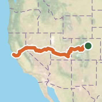
Western American Discovery Trail
Colorado, Utah, Nevada, California, Utah
1,977.4 miLength
220,130 ftElevation gain
StrenuousDifficulty
Point to PointRoute
Open in Sahale GPS
See the trail on the map, download it for offline use and record your hike. The iPhone and Android apps are on their way.
Before you go: trail information can be out of date or wrong, and a trail may be closed or on private land. Check current conditions with the land manager. You hike at your own risk. Full notice
On this hike
- Summits on this hike: Painted Rock, Whale Peak, Relay Peak, Wall Point
- Lakes on this hike: Avery's Pond, Beaver Lake, Black Lake, Briones Reservoir, Cave Lake, Cedar Mesa Reservoir, and 36 more
- Waterfalls on this hike: Devil’s Punch Bowl, Hayes Creek Falls, Indian Creek Fall, 2 unnamed waterfalls
- Rivers and creeks on this hike: American River, Bear Creek, Berry Creek, Big Spring Canyon, Blind Trail Wash, Braderich Creek, and 68 more
- Viewpoints on this hike: Poverty Gulch, Carson Valley Viewpoint, Searle Pass, Norfolk Birdwatching Point, Georgetown Loop Overlook, Lake Ann Pass, and 11 more, 13 unnamed viewpoints
Elevation profile
Low -60 ft1,977.4 miHigh 13,060 ft
Camping nearby
- Group Campground8.5 mi from the trailhead
- Cherry Creek State Park Campground9.0 mi from the trailhead
- Clear Creek RV Park13.8 mi from the trailhead