Appalachian Trail
Green Mountain National Forest, Vermont
A one-way trail of 141.6 mi in Robert T. Stafford White Rocks National Recreation Area, Green Mountain National Forest.
It goes up and down rather than rising steadily: about 32,710 ft of elevation gain along the way, between 380 ft and 3,990 ft.
The steepest stretch is between 103.9 mi and 104.4 mi from the trailhead, gaining 590 ft.
On the way it passes near Griffith Lake, Thundering Brook Falls, Little Rock Pond.
The trailhead is about 3.8 mi north-west of North Adams in a straight line.
Sherman Brook Campsite is within 2 mi of the trailhead.
Described from the map and elevation data.
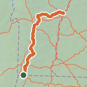
See the trail on the map, download it for offline use and record your hike. The iPhone and Android apps are on their way.
Before you go: trail information can be out of date or wrong, and a trail may be closed or on private land. Check current conditions with the land manager. You hike at your own risk. Full notice
On this hike
- Summits on this hike: Consultation Peak, Peru Peak, Stratton Mountain, Styles Peak, Bear Mountain, Dana Hill, and 5 more
- Lakes on this hike: Little Rock Pond, Griffith Lake, Kent Pond, Connecticut River Reservoir
- Waterfalls on this hike: Thundering Brook Falls, 1 unnamed waterfall
- Rivers and creeks on this hike: Big Black Branch, Big Branch, Bromley Brook, Kent Brook, Little Black Branch, Sargent Brook, and 2 more
- Viewpoints on this hike: Glastenbury Fire Tower, Stratton Fire Tower, Pond & Beaver dam, 7 unnamed viewpoints
Elevation profile
Nearby trails
- Broad Brook Trail7.2 mi · Hard · 1.6 mi away
- Dome Trail3.4 mi · Moderate · 1.7 mi away
- Agawon Trail3.6 mi · Hard · 1.7 mi away
- Dome Summit Trail5 mi · Hard · 1.7 mi away
- State & Town Line Trail1.1 mi · Easy · 1.8 mi away
- Tom's Trail0.7 mi · Easy · 1.8 mi away
Camping nearby
- Sherman Brook Campsite1.8 mi from the trailhead
- Old Seth Warner Shelter Site2.1 mi from the trailhead
- Historic Valley Campground5.2 mi from the trailhead
- Stoney Ledge Group Site7.2 mi from the trailhead