Long Trail
Green Mountain National Forest, Vermont
A one-way trail of 249.1 mi in Mount Mansfield State Forest, Green Mountain National Forest.
It goes up and down rather than rising steadily: about 66,310 ft of elevation gain along the way, between 320 ft and 4,390 ft.
The steepest stretch is between 163.5 mi and 164 mi from the trailhead, gaining 790 ft.
On the way it passes near Griffith Lake, Little Rock Pond, Sterling Pond.
The trailhead is about 17.1 mi north-east of Bennington in a straight line.
Grout Pond Campground is within 2 mi of the trailhead.
Described from the map and elevation data.
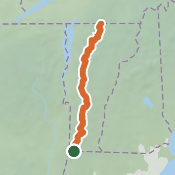
See the trail on the map, download it for offline use and record your hike. The iPhone and Android apps are on their way.
Before you go: trail information can be out of date or wrong, and a trail may be closed or on private land. Check current conditions with the land manager. You hike at your own risk. Full notice
On this hike
- Summits on this hike: Consultation Peak, Doll Peak, Mount Ethan Allen, Mount Mansfield, The Forehead, Camels Hump, and 38 more
- Lakes on this hike: Little Rock Pond, Griffith Lake, Lockwood Pond, Sterling Pond
- Rivers and creeks on this hike: Big Black Branch, Big Branch, Bromley Brook, Little Black Branch, Sargent Brook, Smith Brook, and 2 more
- Viewpoints on this hike: Molly Stark's Balcony, Glastenbury Fire Tower, Stratton Fire Tower, Sunset Ledge, Duxbury Window Viewpoint, Ritterbush Overlook, and 3 more, 11 unnamed viewpoints
Elevation profile
Nearby trails
- Green Mountain National Forest - East Trail3.4 mi · Easy · 0.8 mi away
- Green Mountain National Forest - East Trail1 mi · Easy · 0.8 mi away
- Stratton Pond Trail7.2 mi · Moderate · 0.9 mi away
- Grout Pond - Somerset Reservoir3.9 mi · Easy · 1.3 mi away
- Green Mountain National Forest - East Trail3.9 mi · Easy · 1.3 mi away
- Camp Trail1.6 mi · Easy · 1.3 mi away
Camping nearby
- Grout Pond Campground1.3 mi from the trailhead
- Somerset Airfield7.5 mi from the trailhead
- Camping on the Battenkill9.2 mi from the trailhead
- Howell's Camping area9.9 mi from the trailhead