Appalachian Trail
Virginia
A one-way trail of 533.1 mi in Shenandoah National Park, George Washington National Forest.
It goes up and down rather than rising steadily: about 108,290 ft of elevation gain along the way, between 650 ft and 5,500 ft, ending near Comer’s Creek Falls.
The steepest stretch is between 4.7 mi and 5.2 mi from the trailhead, gaining 460 ft.
On the way it passes near Three Ridges Wilderness, Priest Wilderness, Hunting Camp Creek Wilderness.
The trailhead is about 6.8 mi west of Purcellville in a straight line.
Described from the map and elevation data.
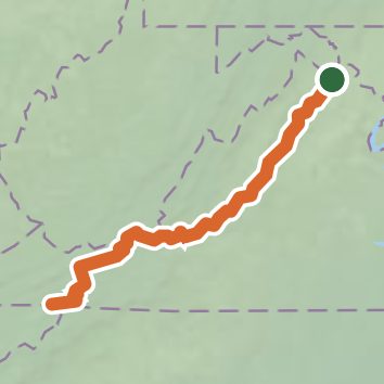
See the trail on the map, download it for offline use and record your hike. The iPhone and Android apps are on their way.
Before you go: trail information can be out of date or wrong, and a trail may be closed or on private land. Check current conditions with the land manager. You hike at your own risk. Full notice
On this hike
- Summits on this hike: Big Rocky Row, Highcock Knob, North Marshall, Bluff Mountain, Calf Mountain, Glade Mountain, and 33 more
- Lakes on this hike: Cushaw Reservoir, Lynchburg Reservoir, Lake Front Royal
- Waterfalls on this hike: Comer’s Creek Falls, Pua Falls, 1 unnamed waterfall
- Rivers and creeks on this hike: Bear Hollow, Big Stony Creek, Brown Mountain Creek, Dismal Creek, Feathercamp Branch, Ivy Creek, and 7 more
- Viewpoints on this hike: Cedar Cliffs, Little Stony Man Overlook, Mills Gap Overlook, Sharp Top Overlook, Montvale Overlook, Tinker Cliffs, and 16 more, 29 unnamed viewpoints
Elevation profile
Nearby trails
- Blackburn Trail1.1 mi · Easy · 4.0 mi away
- Autumn Ridge Pathway1.8 mi · Easy · 4.2 mi away
- Suzanne Kane Nature Preserve Trail0.8 mi · Easy · 6.7 mi away
- Chapman DeMary Trail1 mi · Easy · 6.8 mi away
- Myron Glaser Cabin Access Trail4.1 mi · Moderate · 10.7 mi away
- Old Trail5.3 mi · Hard · 10.9 mi away
Camping nearby
- Blue Ridge Regional Park4.3 mi from the trailhead
- Leave No Trace10.5 mi from the trailhead
- Outback10.8 mi from the trailhead
- Locust Grove11.1 mi from the trailhead