Great Eastern Trail - Tuscarora Trail
Virginia
An out-and-back in Wardensville Wildlife Management Area, George Washington National Forest, 86.4 mi round trip.
It goes up and down rather than rising steadily: about 6,580 ft of elevation gain on the way out, between 610 ft and 2,840 ft.
The steepest stretch is between 10.4 mi and 10.9 mi from the trailhead, gaining 360 ft.
The trailhead is about 10.5 mi north-west of Strasburg in a straight line.
Hawk Campground is within 2 mi of the trailhead.
Described from the map and elevation data.
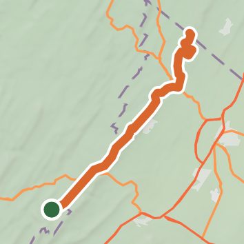
See the trail on the map, download it for offline use and record your hike. The iPhone and Android apps are on their way.
Before you go: trail information can be out of date or wrong, and a trail may be closed or on private land. Check current conditions with the land manager. You hike at your own risk. Full notice
On this hike
- Summits on this hike: Eagle Rock, Pinnacle
- Rivers and creeks on this hike: Back Creek
- Viewpoints on this hike: 1 unnamed viewpoint
Elevation profile
Nearby trails
- Gerhard Shelter Trail7 mi · Hard · 4.0 mi away
- Vances Cove Trail7.6 mi · Hard · 4.0 mi away
- Camp Rock Enon - Red Trail2 mi · Easy · 8.3 mi away
- Camp Rock Enon - Orange Trail1.5 mi · Easy · 8.6 mi away
- Camp Rock Enon - Blue Trail0.5 mi · Easy · 8.7 mi away
- Biby Wilderness Trail1.2 mi · Easy · 9.0 mi away
Camping nearby
- Hawk Campground1.2 mi from the trailhead
- The Cove Campground9.5 mi from the trailhead
- Strasburg Riverlot10.4 mi from the trailhead
- Mudhole Gap Camping13.9 mi from the trailhead