Pacific Northwest Trail
Montana, Idaho, Washington, Washington
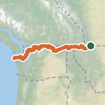
A one-way trail of 1,019.2 mi in Montana, Idaho.
It goes up and down rather than rising steadily: about 142,950 ft of elevation gain along the way, between 0 ft and 7,550 ft, ending near Heart Lake.
The steepest stretch is between 229.1 mi and 229.6 mi from the trailhead, gaining 670 ft.
On the way it passes near Mount Baker Lodge Lakes, Sunrise Lake, Baby Lake.
Described from the map and elevation data.
See the trail on the map, download it for offline use and record your hike. The iPhone and Android apps are on their way.
Before you go: trail information can be out of date or wrong, and a trail may be closed or on private land. Check current conditions with the land manager. You hike at your own risk. Full notice
On this hike
- Summits on this hike: Bunker Hill, Mount Locke, Troxel Hill, Mount Zion, Cougar Mountain, Mount Henry, and 3 more
- Lakes on this hike: Atsina Lake, Baker Lake, Big Beaver Pond, Bonaparte Lake, Bowman Lake, Cosley Lake, and 33 more
- Waterfalls on this hike: Mokowanis Cascade, Paiota Falls, Gros Ventre Falls, 2 unnamed waterfalls
- Rivers and creeks on this hike: Andrews Creek, Antoine Creek, Baker River, Big Beaver Creek, Bogachiel River, Boulder Creek, and 34 more
- Viewpoints on this hike: Bluff Overlook, Samish Overlook, Lookout Tower, 15 unnamed viewpoints
Elevation profile
Camping nearby
- Belly River Campground2.4 mi from the trailhead
- Payne Lake Campground7.6 mi from the trailhead
- Police Outpost Campground9.1 mi from the trailhead
- Fort Heritage & Frontier RV Park9.7 mi from the trailhead