Vesper Peak summit trail
Mount Baker-Snoqualmie National Forest, Washington
6.7 miLength
4,230 ftElevation gain
StrenuousDifficulty
LoopRoute
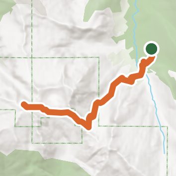
A loop of 6.7 mi in Morning Star Natural Resources Conservation Area, Mount Baker-Snoqualmie National Forest.
It gains 4,230 ft of elevation in all, between a low point of 2,200 ft and a high point of 6,200 ft about 3.3 mi in.
The steepest stretch is between 2.8 mi and 3.3 mi from the trailhead, gaining 1,050 ft.
Described from the map and elevation data.
Open in Sahale GPS
See the trail on the map, download it for offline use and record your hike. The iPhone and Android apps are on their way.
Before you go: trail information can be out of date or wrong, and a trail may be closed or on private land. Check current conditions with the land manager. You hike at your own risk. Full notice
On this hike
- Summits on this hike: Vesper Peak
Elevation profile
Low 2,200 ft6.7 miHigh 6,200 ft
Nearby trails
- Lake Elan Bootpath5.7 mi · Hard · same trailhead
- Sunrise Mine Trail5.4 mi · Hard · same trailhead
- Barlow Point Trail1.8 mi · Moderate · 1.6 mi away
- Railroad Grade0.6 mi · Easy · 1.6 mi away
- Old Monte Cristo Townsite Trail8.7 mi · Hard · 1.6 mi away
- Weden Creek (Gothic Basin) Trail8.4 mi · Strenuous · 1.6 mi away
Camping nearby
- Beaver Creek Group Campground4.4 mi from the trailhead
- Monte Cristo4.6 mi from the trailhead
- Coal Creek Group Camp5.4 mi from the trailhead
- Bedal Campground6.5 mi from the trailhead